CircleGeo is a family safety and location-tracking app that ensures peace of mind through features like real-time location tracking, geofencing, and emergency SOS functionalities. It’s designed to enhance security and driving analytics insights for families.
The Core Idea
Problem
More than 50% of people stay stressed about their family safety, while thriving in a fast-paced world the thought of insecurity and disconnectivity keeps people worried all day long – at work, or out of work. Gabriel was looking for someone who could regard and understand the problem as she has figured out how to create a platform that provides hassle-free and seamless family safety solutions.
Our Approach
Gabriel was keen to solve this burning problem and collaborated with Doerz to build a solution for it. After countless hours of brainstorming sessions and research, we came up with a plan to implement it. Following the LEAN Startup methodology, we prioritized rapid prototyping and continuous user feedback. The development process focused on creating a user-friendly interface that fosters interactions and valuable resources for families.
Our Process for CircleGeo
To address the challenges, the process was designed to:
- Designing a user-friendly interface with real-time location tracking • Implementing a comprehensive process with convenient options for account creation • Providing smart technology for car detection, enabling insights into driving routes and phone usage during drives.
1. Product Ideation
Regular Brainstorm & Discussion to Design the Solution
2. Research, Scope
Gathering Relevant Market Demands & Insights
3. Product Planning & Strategy
Designing a comprehensive implementation plan
4. Product Design & User Experience
Translating concepts into digital assets
5. Product Development
Seamless conversion of designs into usable product

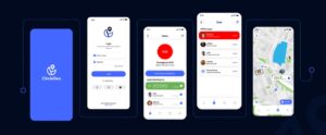
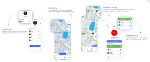
Main Feature Set
Family Profile
~enables you to create a family profile,
adding your family members easily
Location-Tracking
~real-time location tracking shows the
current location of each member on the map
Emergency SOS
~built to fetch help when getting lost
Or lose track of the route
Geofencing
~marking the areas safe/unsafe for
enhanced safety for teenagers/adults.
Design Guide
Development
Final Product